Chatham County | |
|---|---|
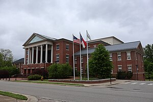
 Chatham County Courthouse in Pittsboro | |
 Location within the U.S. state of North Carolina | |
 North Carolina's location within the U.S. | |
| Coordinates: 35°42′N 79°15′W / 35.70°N 79.25°W | |
| Country | |
| State | |
| Founded | 1771 |
| Named for | William Pitt, 1st Earl of Chatham |
| Seat | Pittsboro |
| Largest community | Siler City |
| Area | |
| • Total | 708.93 sq mi (1,836.1 km2) |
| • Land | 681.68 sq mi (1,765.5 km2) |
| • Water | 27.25 sq mi (70.6 km2) 3.84% |
| Population (2020) | |
| • Total | 76,285 |
| • Estimate (2023) | 81,624 |
| • Density | 111.91/sq mi (43.21/km2) |
| Time zone | UTC−5 (Eastern) |
| • Summer (DST) | UTC−4 (EDT) |
| Congressional district | 9th |
| Website | www |
Chatham County (locally /ˈtʃætəm/ CHAT-əm)[1] is a county located in the Piedmont area of the U.S. state of North Carolina. It is also the location of the geographic center of North Carolina, northwest of Sanford.[2] As of the 2020 census, the population was 76,285.[3] Its county seat is Pittsboro.[4]
Chatham County is part of the Durham-Chapel Hill, NC Metropolitan Statistical Area, which is also included in the Raleigh-Durham-Cary, NC Combined Statistical Area, which had an estimated population of 2,368,947 in 2023.[5]
- ^ Talk Like A Tar Heel Archived June 22, 2013, at the Wayback Machine, from the North Carolina Collection's website at the University of North Carolina at Chapel Hill. Retrieved September 25, 2012.
- ^ "Geographic Centers of the United States" (PDF). pubs.usgs.gov. September 3, 2011. Archived (PDF) from the original on March 24, 2024. Retrieved October 25, 2023.
- ^ Cite error: The named reference
2020CensusQuickFactswas invoked but never defined (see the help page). - ^ "Find a County". National Association of Counties. Archived from the original on May 31, 2011. Retrieved June 7, 2011.
- ^ "Metropolitan and Micropolitan Statistical Areas Population Totals: 2020-2023". United States Census Bureau, Population Division. March 14, 2024. Archived from the original on June 29, 2022. Retrieved March 15, 2024.


