This article has multiple issues. Please help improve it or discuss these issues on the talk page. (Learn how and when to remove these messages)
|
Chathamangalam
(ചാത്തമംഗലം) | |
|---|---|
Village | |
| Coordinates: 12°14′44.1″N 75°26′50.7″E / 12.245583°N 75.447417°E | |
| Country | |
| State | Kerala |
| District | Kannur |
| Languages | |
| • Official | Malayalam, English |
| Time zone | UTC+5:30 (IST) |
| PIN | 670511 |
| Telephone code | 04985- |
| ISO 3166 code | IN-KL |
| Vehicle registration | KL-59- |
| Nearest city | Payyannur |
| Lok Sabha constituency | Kasaragod |

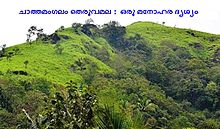
Chathamangalam (ചാത്തമംഗലം), also known as Chathamangalam Hills, Kannur Theruvamala or just Theruvamala, is a hill station village and trekking spot in Kannur district, Kerala, India alongside the Coorg border of the neighbouring Karnataka state, which consists of a vast plain of green grasslands that made it earn the nickname Evergreen Chathamangalam. It is located in the border of Cherupuzha, Alakode and Udayagiri Grama Panchayats.
Chathamangalam is situated almost 58 kilometers away from the district headquarters. Nearby major towns, namely Taliparamba and Payyannur, are at a distance of 35 and 40 kilometers respectively from Chathamangalam. Two major mountains in the region, namely Theruvamala and Thevarkunnumala, have an altitude of approximately 2500 meters from the sea level.
Places like Thirumeni, Thabore, Cherupuzha, Prapoyil, Muthuvom, Padiyottuchal, Udayagiri, Karthikapuram, Parappa(Alakode), Neduvode, Rayarome and Alakode are visible from the hilltop.

