Native name: 赤鱲角 | |
|---|---|
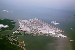
 Aerial view of the airport island in 2010 | |
 Location of Chek Lap Kok in Hong Kong | |
| Geography | |
| Location | North of Lantau Island |
| Coordinates | 22°18′19.1″N 113°55′18.6″E / 22.305306°N 113.921833°E |
| Area | 12.48 km2 (4.82 sq mi) |
| Length | 4 km (2.5 mi) |
| Administration | |
Hong Kong | |
| Chek Lap Kok | |||||||||||||||
|---|---|---|---|---|---|---|---|---|---|---|---|---|---|---|---|
| Traditional Chinese | 赤鱲角 | ||||||||||||||
| Simplified Chinese | 赤𫚭角 | ||||||||||||||
| Literal meaning | Red Perch Cape | ||||||||||||||
| |||||||||||||||

Chek Lap Kok is an island in the western waters of Hong Kong's New Territories. Unlike the smaller Lam Chau, it was only partially leveled when it was assimilated via land reclamation into the 12.48 square kilometres (4.82 sq mi) island for the current Hong Kong International Airport, which opened for commercial aviation in 1998. The airport is popularly referred to as Chek Lap Kok Airport to distinguish it from the former Hong Kong International Airport, now commonly known as Kai Tak Airport.
Hong Kong SkyCity, a business and entertainment complex, is also located on Chek Lap Kok. It includes AsiaWorld–Expo, a convention and exhibition centre, which opened in 2005. Cathay Pacific City, the head office of Cathay Pacific;[1] HAECO,[2] and formerly Hong Kong Airlines[3] are also located on the airport platform.
- ^ "Hong Kong." Cathay Pacific. Retrieved on 8 September 2010.
- ^ "Location Map". HAECO. Archived from the original on 2020-08-02. Retrieved 2020-03-08.
Hong Kong Aircraft Engineering Co. Ltd. (HAECO Group) 80 South Perimeter Road Hong Kong International Airport Lantau, Hong Kong
- ^ "Contact Us > Hong Kong." Hong Kong Airlines. Retrieved on 7 November 2011. "Headquarter Office Address: L2 CNAC House, 12 Tung Fai Road, Hong Kong International Airport, Lantau, Hong Kong"