| Cherokee Park | |
|---|---|
 Cherokee Park, Baringer Hill | |
 | |
| Type | Municipal |
| Location | East Louisville, Kentucky |
| Coordinates | 38°14′28″N 85°41′49″W / 38.24120°N 85.69690°W |
| Area | 409 acres (166 ha) |
| Created | 1891 |
| Operated by | Louisville Metro Parks |
| Website | City's park webpage |
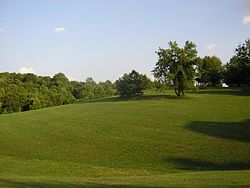
Cherokee Park is a 409-acre (166 ha) municipal park located in Louisville, Kentucky, United States, and is part of the Louisville Olmsted Parks Conservancy. It was designed in 1891 by Frederick Law Olmsted, the father of landscape architecture along with 18 of Louisville's 123 parks. Beargrass Creek runs through much of the park, and is crossed by numerous pedestrian and automobile bridges.
According to The Trust for Public Land, Cherokee Park has 500,000 visitors annually, making it tied for the 69th most popular municipal park in the United States.[1]
The park features a 2.4 mile Scenic Loop through the park's pastoral setting featuring rolling hills, open meadows and woodlands with separate lanes for vehicle traffic (one-way) and recreational users.[2] The park was closed to vehicular traffic during the COVID-19 pandemic, with cars being allowed again after September 2021.[3]
- ^ "America's Most Visited City Parks" (PDF). October 1, 2008. Archived from the original (PDF) on March 31, 2009. Retrieved March 31, 2009.
- ^ "Cherokee Park". Archived from the original on September 2, 2013. Retrieved January 11, 2013.
- ^ Roldan, Roberto (August 26, 2021). "Louisville Metro Council Votes To Fully Reopen Cherokee Park Roads To Cars". Louisville Public Media. Retrieved July 6, 2024.