| Cherry Creek | |
|---|---|
 Rafters on Mushroom Rapid in Cherry Creek, June 2002 | |
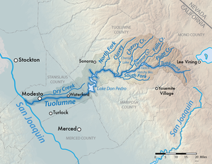
 Map of the Tuolumne River watershed, including Cherry Creek | |
| Location | |
| Country | United States |
| State | California |
| Physical characteristics | |
| Source | Sierra Nevada |
| • location | Emigrant Wilderness, Tuolumne County |
| • coordinates | 38°05′54″N 119°47′23″W / 38.09833°N 119.78972°W[1] |
| • elevation | 7,119 ft (2,170 m) |
| Mouth | Tuolumne River |
• location | West of Mather, Tuolumne County |
• coordinates | 37°53′19″N 119°58′19″W / 37.88861°N 119.97194°W[1] |
• elevation | 2,162 ft (659 m) |
| Length | 27.7 mi (44.6 km)[2] |
| Basin size | 216.3 sq mi (560 km2)[3] |
| Discharge | |
| • location | below Holm Powerplant, near the mouth[4] |
| • average | 694 cu ft/s (19.7 m3/s)[4] |
| • minimum | 1.6 cu ft/s (0.045 m3/s) |
| • maximum | 33,500 cu ft/s (950 m3/s) |
Cherry Creek is a large, swift-flowing[5] stream in the Sierra Nevada mountain range, and is the largest tributary of the Tuolumne River. The creek is 44.6 miles (71.8 km) long measured to its farthest headwaters;[3] the main stem itself is 27.7 miles (44.6 km) long,[3] draining a watershed of 234 square miles (610 km2) in the Stanislaus National Forest. Part of the drainage also extends into the northwest corner of Yosemite National Park.
- ^ a b "Cherry Creek". Geographic Names Information System. United States Geological Survey, United States Department of the Interior. 1981-01-19. Retrieved 2016-10-11.
- ^ Cite error: The named reference
ACMEwas invoked but never defined (see the help page). - ^ a b c United States Geological Survey. National Hydrography Dataset high-resolution flowline data. The National Map, accessed February 2, 2024
- ^ a b "USGS Gage #11278400 on Cherry Creek below Dion R. Holm Powerplant, near Mather, CA: Annual Water-Data Report" (PDF). National Water Information System. U.S. Geological Survey. 2013. Retrieved 2016-10-11.
- ^ "Rafting on Cherry Creek". Archived from the original on 2010-07-09. Retrieved 2010-05-29.