| Cherry River | |
|---|---|
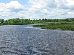
 A riverbend in the Cherry River | |
 | |
| Native name | Rivière aux Cerises (French) |
| Location | |
| Country | Canada |
| Province | Quebec |
| Administrative region | Estrie |
| Physical characteristics | |
| Source | |
| • location | Orford (secteur Saint-Élie d'Orford), Étang de la source |
| Mouth | |
• location | Sherbrooke (secteur Deauville), Lake Memphremagog |
• coordinates | 45°16′13″N 72°10′16″W / 45.27028°N 72.17111°W[1] |
• elevation | 204 m |
| Length | 11.9 km |
| Basin features | |
| Tributaries | |
| • left | Branche de l'Est (East Branch), ruisseau de la Cuvette (Cuvette Creek). |
| • right | Ruisseau du Grand Rocher. |
The Cherry River or Rivière aux Cerises is a river in Magog, Quebec that is part of the Lake Memphremagog watershed. This river flows through the cities Orford, then Magog, in the Memphremagog Regional County Municipality, in the administrative region of Estrie, in Quebec, in Canada.
The river was flooded by the creation of dams in the late 19th century, creating a permanent wetland around it.[2]
- ^ "Banque de noms de lieux du Québec: Reference number 11964". toponymie.gouv.qc.ca (in French). Commission de toponymie du Québec.
- ^ Farfan, Matthew. "The Cherry River Marsh, Magog". Townships Heritage Web Magazine. Retrieved 14 July 2014.