 | |||
| Provincial electoral district | |||
| Legislature | Nova Scotia House of Assembly | ||
| MLA |
Progressive Conservative | ||
| District created | 1956 | ||
| Last contested | 2021 | ||
| Demographics | |||
| Population (2011) | 20,368 | ||
| Electors | 15,291 | ||
| Area (km²) | 1,661 | ||
| Pop. density (per km²) | 12.3 | ||
| Census division(s) | Halifax RM, Lunenburg County | ||
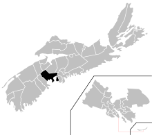
Chester—St. Margaret's is a provincial electoral district in Nova Scotia, Canada, that elects one member of the Nova Scotia House of Assembly. It is located on the South Shore.
The constituency was created in 1956 as a division of Lunenburg County. It was called Lunenburg East from 1956 to 1993. In 1993, the district was renamed Chester—St. Margaret's and gained Tancook Islands from Lunenburg Centre and St. Margaret's Bay from Halifax St. Margarets. In 2003, it gained the communities of West Dover and Bayside. In 2012, the district lost the Upper Tantallon area north of Highway 103 to Hammonds Plains-Lucasville.[1]
The district includes the Municipality of Chester and the communities in the Halifax Regional Municipality along the coast of St. Margarets Bay including Peggys Cove. Major towns in the riding include Hubbards, Chester, Western Shore, Boutiliers Point and Head of St. Margarets Bay.
- ^ Constituency History Nova Scotia Legislature