Chifunde | |
|---|---|
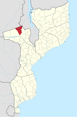
 Chifunde District on the map of Mozambique | |
| Country | Mozambique |
| Province | Tete |
| Capital | Chifunde |
| Area | |
| • Total | 9,403 km2 (3,631 sq mi) |
| Population (2007 census) | |
| • Total | 101,811 |
| • Density | 11/km2 (28/sq mi) |
Chifunde District is a district of Tete Province in western Mozambique. The principal town is Chifunde. The district is located in the north of the province, and borders with Zambia in the north, Malawi in the northeast, Macanga District in the east, Chiuta District in the south, and with Marávia District in the west. The area of the district is 9,403 square kilometres (3,631 sq mi).[1] It has a population of 101,811 as of 2007.[2]
- ^ "Perfil do Distrito de Chifunde" (PDF) (in Portuguese). Ministry of State Administration. 2005. Archived from the original (PDF) on 30 September 2011. Retrieved 23 November 2016.
- ^ "População da Provincia de Tete". Censo 2007 (in Portuguese). Instituto Nacional de Estatística. Archived from the original on 19 December 2007. Retrieved 20 March 2008.