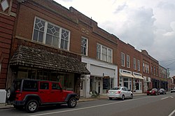
Town of Chilhowie, Virginia | |
|---|---|
 | |
Location in the Commonwealth of Virginia | |
| Coordinates: 36°48′0″N 81°40′52″W / 36.80000°N 81.68111°W | |
| Country | United States |
| State | Virginia |
| County | Smyth |
| Government | |
| • Mayor | Gary Heninger |
| Area | |
| • Total | 2.57 sq mi (6.66 km2) |
| • Land | 2.53 sq mi (6.56 km2) |
| • Water | 0.04 sq mi (0.10 km2) |
| Elevation | 1,952 ft (595 m) |
| Population (2010) | |
| • Total | 1,781 |
| • Estimate (2020)[2] | 1,698 |
| • Density | 671.67/sq mi (259.32/km2) |
| U.S. Census Bureau, 2000 Population Estimates | |
| Time zone | UTC-5 (EST) |
| • Summer (DST) | UTC-4 (EDT) |
| ZIP code | 24319 |
| Area code | 276 |
| FIPS code | 51-16480[3] |
| GNIS feature ID | 1464850[4] |
| Website | http://www.chilhowie.org/ |
Chilhowie /tʃɪlˈhaʊi/ is a town in Smyth County, Virginia, United States, on the Middle Fork of the Holston River. The population was 1,781 at the 2010 census. The name Chilhowie is said to come from a Cherokee word meaning "valley of many deer".[5] It is also notable for having only one traffic light in the entire city. I-81 runs through Chilhowie. It is located at exit 35.
- ^ "2019 U.S. Gazetteer Files". United States Census Bureau. Retrieved August 7, 2020.
- ^ Cite error: The named reference
USCensusEst2019CenPopScriptOnlyDirtyFixDoNotUsewas invoked but never defined (see the help page). - ^ Cite error: The named reference
GR2was invoked but never defined (see the help page). - ^ "US Board on Geographic Names". United States Geological Survey. October 25, 2007. Retrieved January 31, 2008.
- ^ "Town History". chilhowie.org. Town of Chilhowie. Retrieved December 14, 2016.


