Chilpancingo, Guerrero | |
|---|---|
| Chilpancingo de los Bravo | |
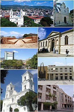
 Above, from left to right: Downtown, Chilpancingo Francisco Assisi Church, Tehuacalco archaeological site, The Civic Plaza "First Congress of Anahuac", Chilpancingo Saint Mary Cathedral, Museo de Regional de Guerrero (Regional Museum of Guerrero), Chilpancingo City Hall and the judiciary. | |
| Nickname: Ciudad Bravo | |
| Coordinates: 17°33′N 99°30′W / 17.550°N 99.500°W | |
| Country | Mexico |
| State | Guerrero |
| Municipality | Chilpancingo de los Bravo |
| Founded | 1 November 1591 |
| Government | |
| • Mayor | Gustavo Alarcón Herrera |
| Area | |
| • Municipality | 2,338.4 km2 (902.86 sq mi) |
| Elevation | 1,253 m (4,111 ft) |
| Population (2020) | |
| • Total | 225 728 |
| • Municipality | 336 480 |
| • Demonym | Chilpancingueño |
| Time zone | UTC−6 (CST) |
| Postal code | 39000-39129 |
| Area code | 747 |
| Website | chilpancingo.gob.mx |
Chilpancingo de los Bravo (commonly shortened to Chilpancingo; Spanish pronunciation: [tʃilpanˈsiŋɡo] ; Nahuatl: Chilpantzinco (pronounced [t͡ʃiɬpanˈt͡siŋko])) is the capital and second-largest city of the Mexican state of Guerrero. In 2010 it had a population of 187,251 people. The municipality has an area of 2,338.4 km2 (902.9 sq mi) in the south-central part of the state, situated in the Sierra Madre del Sur mountains, on the bank of the Huacapa River.[1] The city is on Federal Highway 95, which connects Acapulco to Mexico City. It is served by Chilpancingo National Airport, which is one of the five airports in the state.
- ^ "Chilpancingo". Encyclopædia Britannica. Retrieved 18 September 2014.


