Chinese Camp | |
|---|---|
 Main Street, Chinese Camp | |
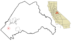
 Location in Tuolumne County and the state of California | |
| Coordinates: 37°52′13″N 120°26′1″W / 37.87028°N 120.43361°W | |
| Country | |
| State | |
| County | Tuolumne |
| Area | |
| • Total | 0.90 sq mi (2.33 km2) |
| • Land | 0.90 sq mi (2.33 km2) |
| • Water | 0.00 sq mi (0.01 km2) 0.28% |
| Elevation | 1,273 ft (388 m) |
| Population (2020) | |
| • Total | 90 |
| • Density | 100.22/sq mi (38.70/km2) |
| Time zone | UTC−08:00 (Pacific (PST)) |
| • Summer (DST) | UTC−07:00 (PDT) |
| ZIP Code | 95309 |
| Area code | 209 |
| FIPS code | 06-13182 |
| GNIS feature ID | 233668 |
| Reference no. | 423[2] |

Chinese Camp is a census-designated place (CDP) in Tuolumne County, California, United States. The population was 126 at the 2010 census, down from 146 at the 2000 census. It lies in the grassy foothills of the Sierra Nevada near the southern end of California's Gold Country.
Chinese Camp is California Historical Landmark #423, since 1949.
- ^ "2020 U.S. Gazetteer Files". United States Census Bureau. Retrieved October 30, 2021.
- ^ "Chinese Camp". Office of Historic Preservation, California State Parks. Retrieved October 18, 2012.
