| Chinit River Stung Chinit, Stoeng Chinith | |
|---|---|
 | |
 | |
| Location | |
| Country | Cambodia |
| Physical characteristics | |
| Source | |
| • location | Kampong Thom Province, Cambodia |
| • coordinates | 12°31′38″N 104°27′31″E / 12.52722°N 104.45861°E |
| • elevation | 1,647 ft (502 m) |
| Mouth | Tonlé Sap River |
• coordinates | 13°32.25′N 105°47.55′E / 13.53750°N 105.79250°E |
• elevation | 16 ft (4.9 m) |
| Length | 164 mi (264 km) |
| Basin size | 1,739 sq mi (4,500 km2) |
| Discharge | |
| • location | Kampong Thmar |
| Basin features | |
| River system | Tonlé Sap |
| Tributaries | |
| • right | Stung Tang Krasaing |
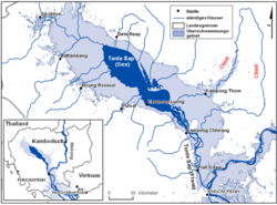
Chinit River (alternates: Stung Chinit or Stoeng Chinith; Khmer: ស្ទឹងជីនិត) is a river of Cambodia. Located in Kampong Thom Province,[1] it is a major tributary of the Tonlé Sap Lake ("Great Lake"), which joins the Tonlé Sap River at the downstream end in the larger Mekong basin. Somewhat unusually the river is looped back into the same river system, which accounts for its length of 264 kilometres (164 mi), leaving Tonlé Sap lake and entering its river again downstream. The prehistoric archaeological site of Samrong Sen is located on the river bank.[1][2] Water resource projects, commencing in 1971 and in 2003, have had various measures of success.[3][4] The river is an important trade route.[5]
- ^ a b Kyoto (1997), pp. 23–31
- ^ Sophady Heng. "A study of polished stone tools from Samrong Sen, Cambodia: the French Museum collections" (pdf). Museologia Scientifica e Naturalistica. Annali dell’Università degli Studi di Ferrara Museologia Scientifica e Naturalistica. ISSN 1824-2707. Retrieved 15 January 2011.
- ^ Water Environment Partnership in Asia. "State of Water: Cambodia". Ministry of the Environment of Japan. Retrieved 19 January 2011.
- ^ Sawada, Haruo; Chappell, N. A.; LaFrankie, J. V. (18 April 2007). Forest environments in the Mekong River Basin. シュプリンガー・ジャパン株式会社. p. 137. ISBN 978-4-431-46500-3. Retrieved 9 January 2011.
- ^ Cite error: The named reference
Mikewas invoked but never defined (see the help page).