Chino Hills, California | |
|---|---|
 Chino Hills, with the San Gabriel Mountains in background | |
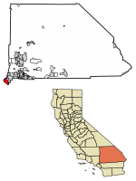
 Location of Chino Hills in San Bernardino County, California | |
| Coordinates: 33°59′38″N 117°45′32″W / 33.99389°N 117.75889°W[1] | |
| Country | United States |
| State | California |
| County | San Bernardino |
| Incorporated (city) | December 1, 1991[2] |
| Government | |
| • Type | Council-Manager |
| • Mayor | Cynthia Moran[3] |
| Area | |
| • Total | 44.70 sq mi (115.77 km2) |
| • Land | 44.65 sq mi (115.64 km2) |
| • Water | 0.05 sq mi (0.12 km2) 0.15% |
| Elevation | 860 ft (262 m) |
| Population (2020) | |
| • Total | 78,411 |
| • Rank | 116th in California |
| • Density | 1,756.13/sq mi (678.05/km2) |
| Time zone | UTC-8 (Pacific) |
| • Summer (DST) | UTC-7 (PDT) |
| ZIP code | 91709 |
| Area code | 909 |
| FIPS code | 06-13214 |
| GNIS feature IDs | 1668255, 2409454 |
| Website | www |
Chino Hills (chino, Spanish for "curly")[5] is a city located in the southwestern corner of San Bernardino County, California, United States. The city borders Los Angeles County on its northwest side, Orange County to its south and southwest, and Riverside County to its southeast.
- ^ a b "Chino Hills". Geographic Names Information System. United States Geological Survey, United States Department of the Interior. Retrieved November 18, 2014.
- ^ "California Cities by Incorporation Date". California Association of Local Agency Formation Commissions. Archived from the original (Word) on November 3, 2014. Retrieved August 25, 2014.
- ^ Cite error: The named reference
citywas invoked but never defined (see the help page). - ^ "2020 U.S. Gazetteer Files". United States Census Bureau. Retrieved October 30, 2021.
- ^ McCombs, Al (July 6, 2019). "Where did Chino's name come from?". Champion Newspapers. Retrieved April 10, 2023.


