| Chippewa River | |
|---|---|
 | |
 | |
| Location | |
| Country | United States |
| State | Michigan |
| Counties | Mecosta, Isabella, Midland |
| Municipalities | Barryton, Mount Pleasant, Midland |
| Physical characteristics | |
| Source | Confluence of North Branch Chippewa River and West Branch Chippewa River |
| • location | Barryton |
| Mouth | Tittabawassee River |
• location | Midland |
• elevation | 600 ft (180 m)[1] |
| Length | 92 mi (148 km) |
| Discharge | |
| • location | mouth |
| • average | 878.46 cu ft/s (24.875 m3/s) (estimate)[2] |
| Basin features | |
| River system | Saginaw River |
| Tributaries | |
| • left | Pine River, West Branch Chippewa River |
| • right | North Branch Chippewa River, Coldwater River |
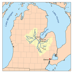
The Chippewa River is a stream in Michigan, United States, that runs 91.8 miles (147.7 km)[3] through the central Lower Peninsula. The Chippewa is a tributary of the Tittabawassee River and is thus part of the Saginaw River drainage basin. The river is named after the Chippewa people (the Saginaw Chippewa Tribal Nation is located in Isabella County).
- ^ "Chippewa River". Geographic Names Information System. United States Geological Survey, United States Department of the Interior.
- ^ United States Environmental Protection Agency. "Watershed Report: Chippewa River". WATERS GeoViewer. Archived from the original on 2021-07-05. Retrieved 2021-07-05.
- ^ U.S. Geological Survey. National Hydrography Dataset high-resolution flowline data. The National Map Archived 2012-03-29 at the Wayback Machine, accessed November 7, 2011