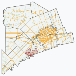
Chippewas of the Thames First Nation 42
Deshkaan-ziibing Aniishinaabeg | |
|---|---|
| Chippewas of the Thames First Nation Indian Reserve No. 42 | |
| Coordinates: 42°50′N 81°29′W / 42.833°N 81.483°W | |
| Country | |
| Province | |
| County | Middlesex |
| First Nation | Chippewas of the Thames |
| Formed | 1819 |
| Government | |
| • Chief | R.K. Joe Miskokomon |
| • Federal riding | Lambton—Kent—Middlesex |
| • Prov. riding | Lambton—Kent—Middlesex |
| Area | |
| • Land | 39.11 km2 (15.10 sq mi) |
| Population (2011)[1] | |
| • Total | 762 |
| • Density | 19.5/km2 (51/sq mi) |
| Time zone | UTC-5 (EST) |
| • Summer (DST) | UTC-4 (EDT) |
| Postal Code | N0L |
| Area code(s) | 519 and 226 |
| Website | www.cottfn.com |
Chippewas of the Thames First Nation (Ojibwe: Deshkaan-ziibing Aniishinaabeg) is an Anishinaabe (Ojibway) First Nations band government located 24 kilometres (15 mi) west of St. Thomas, in southwest Ontario, Canada. Their land base is the 3,652.60 hectares (9,025.8 acres) Chippewas of the Thames First Nation 42 reserve, which almost entirely surrounds the separate reserve of Munsee-Delaware 1. As of January 2014, their registered population is 2,738 people with 957 living on reserve.
Chippewas of the Thames are neighbours with the Munsee-Delaware Nation, and with the Oneida Nation of the Thames who refer to the territory under the jurisdiction of the Ojibway as twaˀkʌnhá·ke.[2]
- ^ a b "Chippewas of the Thames First Nation 42 community profile". 2011 Census data. Statistics Canada. Retrieved 2011-02-18.
- ^ Michelson, K., & Doxtator, M. (2019). ”Chippewa; non-Oneida Indian; on the Chippewa side, at the Chippewa reserve on the other side of the river from Oneida-of- the-Thames”. In Oneida-English/English-Oneida Dictionary (p. 935). essay, University of Toronto.

