| Chitral District ݯھیترارو ضلع ضلع چترال | |||||||||||
|---|---|---|---|---|---|---|---|---|---|---|---|
| District of Pakistan | |||||||||||
| 1947–2018 | |||||||||||
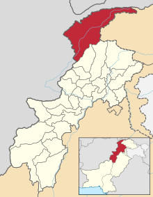
 Map of the former district in Khyber Pakhtunkhwa | |||||||||||
| Capital | Chitral City | ||||||||||
| Demonym | Chitralis | ||||||||||
| Area | |||||||||||
• 1947–2018 | 14,850 km2 (5,730 sq mi) | ||||||||||
| Population | |||||||||||
• 1947–2018 | 414,000 | ||||||||||
| • Type | District Government | ||||||||||
| History | |||||||||||
• Established | 14 August 1947 | ||||||||||
• Establishment of Lower and Upper Chitral | 20 July 2018 | ||||||||||
| Political subdivisions | 6 Tehsils | ||||||||||
| |||||||||||
| Today part of | Pakistan · Lower Chitral & Upper Chitral Districts of Khyber Pakhtunkhwa | ||||||||||
Chitral District (Khowar: ݯھیترارو ضلع; Urdu: ضلع چترال) was a district in the Malakand Division of the Pakistani province of Khyber Pakhtunkhwa, from 14 August 1947 to 2018. It was the largest district in the Khyber-Pakhtunkhwa, covering an area of 14,850 km2, before splitting into Upper and Lower Chitral Districts in 2018.[1] It was the northernmost district of Khyber Pakhtunkhwa.[2] It shared a border with Gilgit-Baltistan to the east and with Swat and Dir districts of Khyber Pakhtunkhwa to the south. It also shared an international border with Afghanistan to the north and west.[3] Afghanistan's narrow strip of Wakhan Corridor separated Chitral from Tajikistan in the north.[4]
- ^ "Upper Chitral gets status of separate district". Dawn newspaper. 21 November 2018. Retrieved 4 November 2023.
- ^ "District Government Chitral". Chitral District Government Web Portl. Archived from the original on 28 September 2015.
- ^ "Governance and Militancy in Afghanistan and Pakistan". Center for Strategic and International Studies (CSIS).
- ^ Nusser, Marcus; Dickoré, Wolf Bernhard (2002). "A Tangle in the Triangle: Vegetation Map of the Eastern Hindukush (Chitral, Northern Pakistan)" (PDF). Erdkunde. 56 (1): 37–59. doi:10.3112/erdkunde.2002.01.03. JSTOR 23218603.