Chlef
الشلف | |
|---|---|
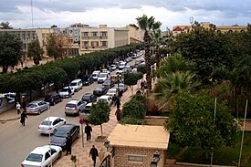
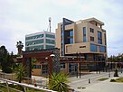
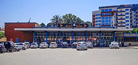
Clockwise from top: Wilaya headquarters Chlef Province, Ibn Badis Street, Solidarity place in downtown Chlef, The Islamic Cultural Center in downtown Chlef, Mirador Hotel, Train station street, Train station in Chlef. | |
 Location of Chlef, Algeria within Chlef Province | |
| Coordinates: 36°09′53″N 01°19′54″E / 36.16472°N 1.33167°E | |
| Country | |
| Province | Chlef |
| District | Chlef |
| Elevation | 114 m (374 ft) |
| Population (2008)[1] | |
• Total | 178,616 |
| Time zone | UTC+1 (CET) |
| Postal code | 02000 |
| Climate | Csa |
Chlef (Arabic: الشلف) is the capital of Chlef Province, Algeria. Located in the north of Algeria, 200 kilometres (120 mi) west of the capital, Algiers, it was founded in 1843, as Orléansville, on the ruins of Roman Castellum Tingitanum. In 1962, it was renamed al-Asnam, but after the devastating earthquake on October 10, 1980,[2] it has borne its present name, Chlef, which is derived from the name of the Chelif River, the longest river in Algeria.
It is home to the soccer club ASO Chlef, the Hassiba Ben Bouali university, and the ruins of the basilica of Reparatus, who was bishop of Castellum Tingitanum from 465 to 475. A corner of the flooring of the basilica contained a mosaic labyrinth, the oldest known example of Christian use of this motif.
- ^ "Répartition de la population résidente des ménages ordinaires et collectifs, selon la commune de résidence et la dispersion" (PDF). The Algerian National Office of Statistics. Retrieved 27 October 2021.
- ^ Hichem (10 October 2018). "Séisme 10 octobre 1980 : Chlef s'en souvient encore" (in French). Algérie 360°.


