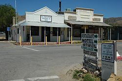
Chloride, Arizona | |
|---|---|
 Chloride town center | |
 Location in Mohave County, Arizona | |
| Coordinates: 35°24′52″N 114°11′58″W / 35.41444°N 114.19944°W | |
| Country | United States |
| State | Arizona |
| County | Mohave |
| Founded | 1863 |
| Area | |
| • Total | 1.51 sq mi (3.90 km2) |
| • Land | 1.51 sq mi (3.90 km2) |
| • Water | 0.00 sq mi (0.00 km2) |
| Elevation | 4,022 ft (1,226 m) |
| Population | |
| • Total | 229 |
| • Density | 151.96/sq mi (58.67/km2) |
| Time zone | UTC-7 (MST (no DST)) |
| ZIP code | 86431 |
| FIPS code | 04-12910 |
Chloride is a onetime silver mining camp in Mohave County, Arizona, United States, and is considered the oldest continuously inhabited mining town in the state.[4] The town is a census-designated place (CDP), with a population at the 2020 census of 229.[3] Chloride has a ZIP Code of 86431.
The town is located on the southwest flank of the Cerbat Mountains, 23 miles (37 km) northwest of Kingman, the Mohave county seat. Grasshopper Junction is 4 miles (6 km) to the west on U.S. Route 93.[5]
- ^ "2021 U.S. Gazetteer Files: Arizona". United States Census Bureau. Retrieved May 19, 2022.
- ^ U.S. Geological Survey Geographic Names Information System: Chloride
- ^ a b "Chloride CDP, Arizona: 2020 DEC Redistricting Data (PL 94-171)". U.S. Census Bureau. Retrieved May 19, 2022.
- ^ "Chloride History". Chloride Chamber of Commerce. Archived from the original on February 3, 2015. Retrieved September 3, 2007.
- ^ Arizona Atlas & Gazetteer, DeLorme, 4th edition, 2001, p. 28 ISBN 0899333257

