| Chocolate Hills | |
|---|---|
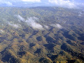
 Aerial view of the Chocolate Hills | |
| Highest point | |
| Elevation | 120 m (390 ft) |
| Coordinates | 9°55′N 124°10′E / 9.917°N 124.167°E |
| Naming | |
| Native name | Mga Bungtod sa Tsokolate (Cebuano) |
| Geography | |
| Settlement | |
| Geology | |
| Rock age | Late Pliocene to Early Pleistocene |
| Mountain type | Conical karst hill range |
The Chocolate Hills (Cebuano: Mga Bungtod sa Tsokolate, Filipino: Mga Tsokolateng Burol or Mga Burol na Tsokolate) are a geological formation in the Bohol province of the Philippines.[1] There are at least 1,260 hills, but there may be as many as 1,776 hills spread over an area of more than 50 square kilometers (20 sq mi).[2] They are covered in green grass that turns into a chocolate-like brown during the dry season, hence the name.
They are featured in the provincial flag and seal to symbolize the abundance of natural attractions in the province.[3] They are in the Philippine Tourism Authority's list of tourist destinations in the Philippines;[4] they have been declared the country's third National Geological Monument and proposed for inclusion in the UNESCO World Heritage List.[4]
- ^ Eye on the Philippines Archived December 8, 2006, at the Wayback Machine Global Eye Retrieved December 22, 2006.
- ^ Chocolate Hills Archived April 9, 2015, at the Wayback Machine Seven Natural Wonders. Retrieved December 10, 2011.
- ^ The Bohol Flag and Seal Archived April 8, 2007, at the Wayback Machine www.bohol.gov.ph Retrieved November 15, 2006.
- ^ a b Chocolate Hills Natural Monument Archived February 10, 2021, at the Wayback Machine UNESCO World Heritage Centre Retrieved November 14, 2006.

