This article needs additional citations for verification. (February 2022) |
| Choloki | |
|---|---|
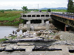
 Bridge over the Choloki blown up during the 2004 Adjara crisis. | |
| Native name | ჩოლოქი (Georgian) |
| Location | |
| Country | Georgia |
| Adjara | |
| Physical characteristics | |
| Source | Caucasus Mountains |
| Mouth | Natanebi |
• coordinates | 41°54′38″N 41°46′12″E / 41.91056°N 41.77000°E |
| Length | 29.5 km (18.3 mi) |
| Basin size | 159 km2 (61 sq mi) |
| Basin features | |
| Progression | Natanebi→ Black Sea |
| Tributaries | |
| • left | Ochkhamuri |
The Choloki[1] (Georgian: ჩოლოქი, also Cholok) in Georgia forms the border between the autonomous province of Ajaria and the province of Guria. For a time in the 19th century it formed the border between Turkey and Imperial Russia.
