| Cholsey | |
|---|---|
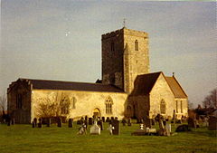
 St Mary's parish church | |
Location within Oxfordshire | |
| Area | 16.52 km2 (6.38 sq mi) [1] |
| Population | 3,457 (2011 Census) |
| • Density | 209/km2 (540/sq mi) |
| OS grid reference | SU5886 |
| • London | 45 mi (72 km) |
| Civil parish |
|
| District | |
| Shire county | |
| Region | |
| Country | England |
| Sovereign state | United Kingdom |
| Post town | Wallingford |
| Postcode district | OX10 |
| Dialling code | 01491 |
| Police | Thames Valley |
| Fire | Oxfordshire |
| Ambulance | South Central |
| UK Parliament | |
| Website | Cholsey Parish Council |
Cholsey is a village and civil parish immediately south of Wallingford in South Oxfordshire. Its population in 2011 was 3,457.[2] 2011 Census. Its parish boundary, some 17 miles (27 km) long, reaches from the edge of Wallingford into the Berkshire Downs. The village green called "The Forty" has a substantial and ancient walnut tree.
Winterbrook, historically the northern part of Cholsey, was absorbed into Wallingford in 2015. Winterbrook Bridge in the parish carries the Wallingford by-pass across the River Thames. The author Dame Agatha Christie, Lady Mallowen, lived at Winterbrook House until her death. John Masefield, poet laureate, lived at Lollingdon Farm in Cholsey from 1915 to 1917. Cholsey was transferred from Wallingford Rural District in Berkshire to the district of South Oxfordshire in 1974.
- ^ United Kingdom Census 2011; note, reduced figure, less Winterbrook, not known.
- ^ UK Census (2011). "Local Area Report – Cholsey Parish (E04008115)". Nomis. Office for National Statistics. Retrieved 6 December 2019.
