| Chota Nagpur Division | |||||||||||
|---|---|---|---|---|---|---|---|---|---|---|---|
| Division of British India | |||||||||||
| 1854–1947 | |||||||||||
|
Flag | |||||||||||
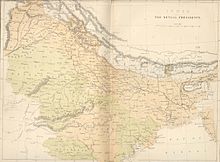
 1858 map of the Bengal Presidency with the 'South-West Frontier States' in the SW | |||||||||||
| Capital | Ranchi | ||||||||||
| Area | |||||||||||
• 1901 | 70,161 km2 (27,089 sq mi) | ||||||||||
| Population | |||||||||||
• 1901 | 4,900,429 | ||||||||||
| Historical era | Modern Period | ||||||||||
• Creation of the division | 1854 | ||||||||||
| 1947 | |||||||||||
| |||||||||||
| Today part of | Bihar Jharkhand Odisha Chhattisgarh | ||||||||||

Chota Nagpur Division, also known as the South-West Frontier, was an administrative division of British India. It included most of the present-day state of Jharkhand as well as adjacent portions of West Bengal, Orissa, and Chhattisgarh.
