Christopher Creek, Arizona | |
|---|---|
 | |
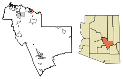
 Location of Christopher Creek in Gila County, Arizona. | |
| Coordinates: 34°21′17.98″N 111°1′17.90″W / 34.3549944°N 111.0216389°W | |
| Country | |
| State | |
| County | Gila |
| Area | |
| • Total | 3.14 sq mi (8.13 km2) |
| • Land | 3.14 sq mi (8.13 km2) |
| • Water | 0.00 sq mi (0.00 km2) |
| Elevation | 5,961 ft (1,817 m) |
| Population (2020) | |
| • Total | 121 |
| • Density | 38.55/sq mi (14.88/km2) |
| Time zone | UTC−7 (MST) |
| • Summer (DST) | UTC−7 (no DST/PDT) |
| ZIP code | 85541 |
| Area code | 928 |
| FIPS code | 04-13140 |
| GNIS ID(s) | 2582755 |
Christopher Creek is a census-designated place in northern Gila County in the U.S. state of Arizona. Situated at the base of the Mogollon Rim, the community lies at an elevation of 5,961 feet (1,817 m),[2] and is located approximately 23.5 miles (37.82 km) northeast of Payson, just off SR 260. The population as of the 2010 U.S. Census was 156.[3]
Tourism, retirement and timbering are the foundations of Christopher Creek's economy.
- ^ "2020 U.S. Gazetteer Files". United States Census Bureau. Retrieved October 29, 2021.
- ^ a b "Feature Detail Report for: Christopher Creek". Geographic Names Information System. United States Geological Survey, United States Department of the Interior.
- ^ "2010 Census Interactive Population Search". census.gov. Archived from the original on April 13, 2014. Retrieved April 13, 2014.

