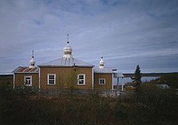
Chuathbaluk
Curarpalek | |
|---|---|
 | |
| Coordinates: 61°34′32″N 159°14′50″W / 61.57556°N 159.24722°W | |
| Country | United States |
| State | Alaska |
| Census area | Bethel |
| Incorporated | 1975[1] |
| Government | |
| • Mayor | Robert Golley, Jr.[2] |
| • State senator | Lyman Hoffman (D) |
| • State rep. | Bryce Edgmon (I) |
| Area | |
| • Total | 6.22 sq mi (16.12 km2) |
| • Land | 4.47 sq mi (11.58 km2) |
| • Water | 1.75 sq mi (4.54 km2) |
| Elevation | 154 ft (47 m) |
| Population (2020) | |
| • Total | 104 |
| • Density | 23.27/sq mi (8.98/km2) |
| Time zone | UTC-9 (Alaska (AKST)) |
| • Summer (DST) | UTC-8 (AKDT) |
| ZIP code | 99557[4] |
| Area code | 907 |
| FIPS code | 02-14330 |
| GNIS feature ID | 1400376 |
Chuathbaluk[pronunciation?] (Central Yupik: Curarpalek[pronunciation?]) is a city in Bethel Census Area, Alaska, United States.
At the 2010 census the population was 118,[5] down from 119 in 2000.
- ^ 1996 Alaska Municipal Officials Directory. Juneau: Alaska Municipal League/Alaska Department of Community and Regional Affairs. January 1996. p. 39.
- ^ 2023 Alaska Municipal Officials Directory (PDF). Juneau: Alaska Municipal League. January 2023. p. 56. Retrieved November 12, 2023.
- ^ "2020 U.S. Gazetteer Files". United States Census Bureau. Retrieved October 29, 2021.
- ^ "Chuathbaluk AK ZIP Code". zipdatamaps.com. 2023. Retrieved June 16, 2023.
- ^ "Geographic Identifiers: 2010 Demographic Profile Data (G001): Chuathbaluk city, Alaska". U.S. Census Bureau, American Factfinder. Archived from the original on February 12, 2020. Retrieved September 18, 2013.
