| Chumbi Valley | |
|---|---|
| Dromo, Tromo, Jumo | |
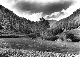
 Chumbi Valley, 1938. | |
 | |
| Floor elevation | 3,000 m (9,800 ft) |
| Long-axis direction | north-south |
| Naming | |
| Native name | གྲོ་མོ (Standard Tibetan) |
| Geography | |
| Location | North Eastern Region, India |
| Population centers | Phari, Yatung |
| Rivers | Amo Chhu |
| Chumbi Valley | |||||||
|---|---|---|---|---|---|---|---|
| Chinese | 春丕河谷 | ||||||
| |||||||
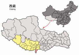
The Chumbi Valley, called Dromo or Tromo in Tibetan,[2][3] is a valley in the Himalayas that projects southwards from the Tibetan plateau, intervening between Sikkim and Bhutan.[4] It is coextensive with the administrative unit Yadong County in the Tibet Autonomous Region of China.[2] The Chumbi Valley is connected to Sikkim to the southwest via the mountain passes of Nathu La and Jelep La.
The valley is at an altitude of 3,000 m (9,800 ft), and being on the south side of the Himalayas, enjoys a wetter and more temperate climate than most of Tibet. The valley supports some vegetation in the form of the Eastern Himalayan broadleaf forests and transitions to the Eastern Himalayan alpine shrub and meadows in the north. The plant Pedicularis chumbica (春丕马先蒿) is named after the valley.
The 1904 Younghusband Expedition of British India passed through the Chumbi Vally on its way to Lhasa. At the end of the expedition, the British took control of the Chumbi Valley in lieu of a war indemnity. China agreed to pay the indemnity owed by the Tibetans in three installments and the Chumbi Valley was transferred back to Tibet on 8 February 1908.[2][5]
- ^ "Brahmaputra River System". Government of Assam, Water Resources.
- ^ a b c Cite error: The named reference
Historical Dictionarywas invoked but never defined (see the help page). - ^ Cite error: The named reference
McKaywas invoked but never defined (see the help page). - ^ "Sikkim impasse: What is the India-China-Bhutan border standoff?". 5 July 2017.
- ^ Great Britain. Foreign Office, East India (Tibet) (1904), p. 143.