| Churchill Lake | |
|---|---|
 Churchill Lake at Buffalo Narrows | |
 | |
| Location | Saskatchewan |
| Coordinates | 55°55′N 108°20′W / 55.917°N 108.333°W |
| Type | Glacial lake |
| Part of | Churchill River drainage basin |
| Primary inflows | Peter Pond Lake, Frobisher Lake, McLusky River |
| Primary outflows | Churchill River to Lac Île-à-la-Crosse |
| Catchment area | 7,874 km2 (3,040 sq mi) |
| Basin countries | Canada |
| Surface area | 559 km2 (216 sq mi) |
| Average depth | 9 m (30 ft) |
| Max. depth | 24 m (79 ft) |
| Water volume | 4.88 km3 (1.17 cu mi) |
| Shore length1 | 212 km (132 mi) |
| Surface elevation | 421 m (1,381 ft) |
| Settlements | Buffalo Narrows |
| References | [2][3] |
| 1 Shore length is not a well-defined measure. | |
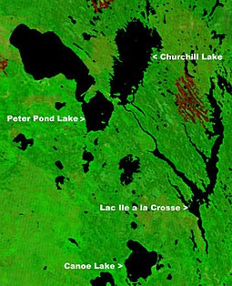
Churchill Lake[4] is a glacial lake in the north-west part of the Canadian province of Saskatchewan. Frobisher Lake flows in from the north while Peter Pond Lake flows in from the east through the Kisis Channel. Highway 155 crosses this channel at the village of Buffalo Narrows .
It is part of the Churchill River drainage basin. As the source of the Churchill River, the length of the river 1,609 kilometres (1,000 mi) is measured from the north end of the lake to the Hudson Bay. The lake can freeze from as early as November and remain frozen till May.[2]
- ^ "NASA Visible Earth (BURN SCARS IN SASKATCHEWAN, CANADA) Note: Dark to light rust coloured areas are burn scars from forest fires". 24 August 2002. Retrieved 14 September 2014.
- ^ a b "World Lake Database (Churchill Lake)". Archived from the original on 20 September 2015. Retrieved 13 October 2012.
- ^ "The Atlas of Canada". Archived from the original on 6 October 2012. Retrieved 13 October 2012.
- ^ "Churchill Lake". Canadian Geographical Names Database. Government of Canada. Retrieved 14 January 2023.

