| Ci Liwung Sungai Ciliwung, Tji Liwoeng, Tjiliwoeng, Tjiliwung | |
|---|---|
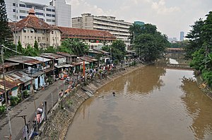
 Lower Ci Liwung at Jakarta | |
| Location | |
| Country | Indonesia |
| Provinces | West Java, Jakarta |
| Cities | Jakarta, Depok, Bogor |
| Physical characteristics | |
| Source | |
| • location | Mount Pangrango, Bogor Regency, West Java, Indonesia |
| • coordinates | 6°44′23″S 106°56′59″E / 6.739846°S 106.949692°E |
| • elevation | 3,002 m (9,849 ft) |
| Mouth | |
• location | North Jakarta, Jakarta, Indonesia |
• coordinates | 6°07′00″S 106°49′42″E / 6.11667°S 106.82833°E |
• elevation | 0 m (0 ft) |
| Length | 119 km (74 mi) |
| Basin size | 375 km2 (145 sq mi) |
| [1] | |

The Ciliwung (often written as Ci Liwung as the "ci" prefix simply translates as "river"; also as Tjiliwoeng in Dutch, Sundanese: ᮎᮤᮜᮤᮝᮥᮀ) is a 119 km long river in the northwestern region of Java where it flows through two provinces, West Java and the special region of Jakarta. The natural estuary of the Ciliwung, known as the Kali Besar ("Big River"), was an important strategic point for trade in the precolonial and colonial periods and was instrumental in the founding of the port city of Jakarta, but has been lost from a reorganization of the watercourse of the rivers around the area into canals.
- ^ DPRI Ciliwung Archived 2013-12-03 at the Wayback Machine

