| Cima Tosa | |
|---|---|
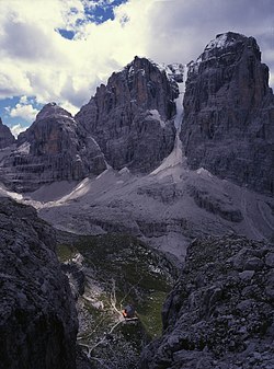
 Cima Tosa and Crozzon di Brenta | |
| Highest point | |
| Elevation | 3,136 m (10,289 ft)[1] |
| Prominence | 589 m (1,932 ft)[2] |
| Listing | |
| Coordinates | 46°09′20″N 10°52′19″E / 46.15556°N 10.87194°E |
| Geography | |
| Location | Trentino-Alto Adige/Südtirol, Italy |
| Parent range | Brenta group, Rhaetian Alps |
| Climbing | |
| First ascent | 18-07-1865 |
| Easiest route | Via Normale from east |
Cima Tosa is a mountain in the Brenta group (It.: Dolomiti di Brenta), a subgroup of the Rhaetian Alps in the Italian Region of Trentino-Alto Adige, with a reported height of 3,136 metres (10,289 ft).[3] it is the second highest peak of the Brenta group in the southern limestone Alps after the Cima Brenta.
The height of the summit marked on the IGM maps is 3,173 m,[4] which would make it the highest peak in the Brenta Dolomites. An electronic measurement campaign in 2015 [5] determined the new height. The change could be linked to the partial melting of the ice cap that covers it. Being the second highest peak of the Brenta group also changed Cima Tosa's prominence making its prominence 589 m above the Bocca di Brenta.
The mountain rises above Val Rendena with its 800-metre (2,600 ft) vertical north face with a steep couloir called Canalone della Tosa dividing it from its ante-peak, Crozzon di Brenta. The summit is topped by a snow cupola above the rock face, almost like a shaven head, hence the name Cima Tosa (Iocal dialect: Shaven Summit). The south-eastern side descends in a series of snowy terraces and vertical rock pillars.
- ^ Portale Geocartografico Trentino, Provincia autonoma di Trento
- ^ Peakbagger Cima Tosa page, Peakbagger
- ^ Portale Geocartografico Trentino, Provincia autonoma di Trento
- ^ Castiglioni-Buscaini, TCI-CAI Guida dei Monti d'Italia: Dolomiti di Brenta (1977), page 241
- ^ Michele Stighen (14 June 2015). "Sorpresa: Cima Tosa non è più la vetta "regina" del Brenta".
