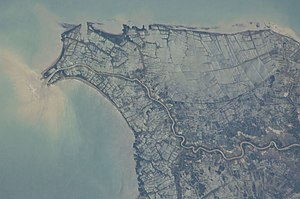
| Tarum River | |
|---|---|
 Estuary of the Tarum river, with mangrove forests at its mouth | |
 | |
| Native name | ᮝᮜᮥᮍᮔ᮪ ᮎᮤᮒᮛᮥᮙ᮪ (Sundanese) |
| Location | |
| Country | |
| State | West Java |
| Physical characteristics | |
| Source | Situ Cisanti; Mt. Wayang; Mt. Kendang |
| • location | Tarumajaya, Bandung Regency, West Java |
| • elevation | 1,600 m (5,200 ft) |
| Mouth | Jakarta Bay; Java Sea |
• location | Muara Gembong, Bekasi Regency, West Java |
• coordinates | 5°56′29″S 106°59′16″E / 5.941306°S 106.987722°E |
| Length | 270 km (170 mi)[1] |
| Basin size | 6,906 km2 (2,666 sq mi)[2] |
| Discharge | |
| • location | Near mouth |
| • average | 423 m3/s (14,900 cu ft/s) |
| Basin features | |
| River system | Citarum basin (DAS220047)[2] |
| Waterbodies | Jatiluhur dam; Cirata dam; Saguling dam |
| Basin management | BPDAS Citarum-Ciliwung[2] |
The Citarum River (more correctly called the Tarum River, as the prefix "Ci" simply means "river") (Sundanese: Walungan Citarum) is the longest and largest river in West Java, Indonesia.[3] It is the third longest river in Java, after Bengawan Solo and Brantas. It plays an important role in the life of the people of West Java. It has been noted for being considered one of the most polluted rivers in the world.[4]

- ^ Citarum River Basin Management (retrieved 2020-05-20)
- ^ a b c "Keputusan Menteri Kehutanan Nomor SK.511/MENHUT-V/2011 Tahun 2011 - Pusat Data Hukumonline".
- ^ "Citarum Nadiku, Mari Rebut Kembali" (in Indonesian). Greenpeace. Archived from the original on 29 March 2019. Retrieved 4 March 2014.
- ^ Holder, Kristen (25 April 2022). "13 of the Most Polluted Rivers in the World: 2 are in the USA!". a-z-animals.com. Retrieved 2022-12-16.