| City of Armadale Western Australia | |||||||||||||||
|---|---|---|---|---|---|---|---|---|---|---|---|---|---|---|---|
 The City of Armadale council chambers | |||||||||||||||
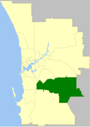
 The City of Armadale within the Perth Metropolitan Area | |||||||||||||||
 | |||||||||||||||
| Population | 94,184 (LGA 2021)[1] | ||||||||||||||
| Established | 1894 | ||||||||||||||
| Area | 559.5 km2 (216.0 sq mi) | ||||||||||||||
| Mayor | Ruth Butterfield | ||||||||||||||
| Council seat | Armadale | ||||||||||||||
| Region | South East Metropolitan Perth; Darling Scarp | ||||||||||||||
| State electorate(s) | Armadale, Darling Range, Southern River | ||||||||||||||
| Federal division(s) | Burt, Canning | ||||||||||||||
 | |||||||||||||||
| Website | City of Armadale | ||||||||||||||
| |||||||||||||||
The City of Armadale is a local government area in the southeastern suburbs of the Western Australian capital city of Perth, about 28 kilometres (17.4 mi) southeast of Perth's central business district. The City covers an area of 560 square kilometres (216 sq mi), much of which is state forest rising into the Darling Scarp to the east, and had a population of almost 80,000 as at the 2016 Census. At the 2021 census, the population had risen to 94,184.
- ^ Australian Bureau of Statistics (28 June 2022). "Armadale (Local Government Area)". Australian Census 2021 QuickStats. Retrieved 28 June 2022.