| City of Greater Dandenong Victoria | |||||||||||||||
|---|---|---|---|---|---|---|---|---|---|---|---|---|---|---|---|
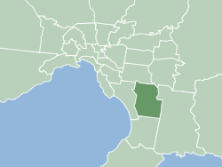
 The City of Greater Dandenong within metropolitan Melbourne | |||||||||||||||
| Coordinates | 38°01′0″S 145°20′38″E / 38.01667°S 145.34389°E | ||||||||||||||
| Population | 166,094 (2018)[1] (43rd) | ||||||||||||||
| • Density | 1,280/km2 (3,310/sq mi) | ||||||||||||||
| Established | 1994 | ||||||||||||||
| Area | 130 km2 (50.2 sq mi)[1] | ||||||||||||||
| Mayor | Eden Foster | ||||||||||||||
| Council seat | Dandenong | ||||||||||||||
| Region | Greater Melbourne | ||||||||||||||
| State electorate(s) | |||||||||||||||
| Federal division(s) | |||||||||||||||
 | |||||||||||||||
| Website | City of Greater Dandenong | ||||||||||||||
| |||||||||||||||
The City of Greater Dandenong is a local government area in Victoria, Australia in the southeastern suburbs of Melbourne. It has an area of just under 130 square kilometres (50 sq mi) and 166,094 residents in 2018.[1] 29% of its land area forms part of the South East Green Wedge. It was formed in 1994 by the merger of parts of the former City of Dandenong and City of Springvale.
The Bunurong/Boon Wurrung and Wurundjeri peoples are the traditional owners and custodians of the land on which Greater Dandenong is now located.[2]
- ^ a b c "3218.0 – Regional Population Growth, Australia, 2017-18: Population Estimates by Local Government Area (ASGS 2018), 2017 to 2018". Australian Bureau of Statistics. Australian Bureau of Statistics. 27 March 2019. Retrieved 25 October 2019. Estimated resident population, 30 June 2018.
- ^ "City of Greater Dandenong Reconciliation Action Plan Dec 2017-2019". Retrieved 5 July 2021.