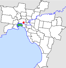
| City of Port Melbourne Victoria | |||||||||||||||
|---|---|---|---|---|---|---|---|---|---|---|---|---|---|---|---|
 Location in Melbourne | |||||||||||||||
 The former Port Melbourne Town Hall | |||||||||||||||
| Population | 7,900 (1992)[1] | ||||||||||||||
| • Density | 744/km2 (1,927/sq mi) | ||||||||||||||
| Established | 1860 | ||||||||||||||
| Area | 10.62 km2 (4.1 sq mi) | ||||||||||||||
| Council seat | Port Melbourne | ||||||||||||||
| Region | Inner Melbourne | ||||||||||||||
| County | Bourke | ||||||||||||||
 | |||||||||||||||
The City of Port Melbourne was a local government area about 4 kilometres (2 mi) southwest of Melbourne, the state capital of Victoria, Australia, on the south bank of the Yarra River. The city covered an area of 10.62 square kilometres (4.10 sq mi), and existed from 1860 until 1994.
The council area covered the current boundaries of the suburb of Port Melbourne; the Yarra River to the west and north, Boundary Street to the northeast, Hobsons Bay to the south and Pickles Street to the east.[2]