| City of Rocks National Reserve | |
|---|---|
IUCN category V (protected landscape/seascape) | |
 | |
| Location | Cassia County, Idaho, United States |
| Nearest city | Oakley, Idaho |
| Coordinates | 42°04′12″N 113°42′45″W / 42.0698842°N 113.7124104°W[1] |
| Area | 14,407 acres (58.30 km2)[2] |
| Elevation | 6,260 ft (1,910 m)[1] |
| Designation | United States National Reserve |
| Established | November 18, 1988 |
| Visitors | 130,276 (in 2017)[3] |
| Governing body | National Park Service & Idaho Department of Parks and Recreation |
| Website | City of Rocks National Reserve |
| Designated | 1974[4] |
| Designated | 1964[5] |
| Reference no. | 66000308 |
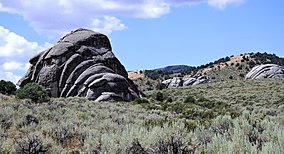
The City of Rocks National Reserve, also known as the Silent City of Rocks, is a United States National Reserve and state park in south-central Idaho, approximately 2 miles (3.2 km) north of the border with Utah. It is widely known for its enormous granite rock formations and excellent rock climbing.
The rock spires in the City of Rocks and adjacent Castle Rocks State Park are largely composed of granitic rock of the Oligocene Almo pluton and Archean Green Creek Complex. City of Rocks is also a popular rock climbing area, with over 1,000[6] traditional and bolt-protected routes. In the 1980s, it was home to some of the most difficult routes in the country, mostly developed by Idaho climber Tony Yaniro.[citation needed] Climbers in the region refer to the area as simply "The City".
During the 1840s and 1850s, wagon trains on the California Trail left the Raft River valley and traveled through the area and over Granite Pass into Nevada. Names or initials of emigrants written in axle grease are still visible on Register Rock, and ruts from wagon wheels can be seen in some of the rocks.
- ^ a b "City of Rocks National Reserve". Geographic Names Information System. United States Geological Survey, United States Department of the Interior.
- ^ "Listing of acreage – December 31, 2011" (XLSX). Land Resource Division, National Park Service. Retrieved December 14, 2012. (National Park Service Acreage Reports)
- ^ Cite error: The named reference
visitswas invoked but never defined (see the help page). - ^ Cite error: The named reference
nnlwas invoked but never defined (see the help page). - ^ Cite error: The named reference
nrhpwas invoked but never defined (see the help page). - ^ "City of Rocks Climbing guidebook".

