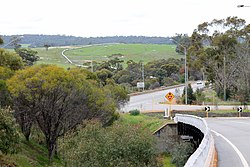
Clackline Bridge | |
|---|---|
 View along Clackline Bridge in 2012, with the Goldfields Pipeline visible in the background | |
| Coordinates | 31°43′14″S 116°31′18″E / 31.7206°S 116.5218°E |
| Carries | Motor vehicles |
| Crosses | Clackline Brook |
| Locale | Clackline, Western Australia |
| Owner | State of Western Australia |
| Maintained by | Main Roads Western Australia and Shire of Northam |
| Heritage status | State Heritage Register permanent entry |
| Structure Number | 0608 |
| Characteristics | |
| Design | Inclined curvilinear |
| Material | Timber |
| Total length | 133.6 m (438 ft) |
| Width | 8.98 m (29.5 ft) |
| Longest span | 14.2 m (47 ft) |
| No. of spans | 18 |
| Piers in water | 18 |
| History | |
| Designer | Ernest Godfrey |
| Constructed by | Main Roads Department |
| Construction start | January 1935 |
| Construction cost | £9000 |
| Opened | 30 August 1935 |
| Statistics | |
| Official name | Clackline Bridge |
| Type | State Registered Place |
| Designated | 18 November 2008 |
| Reference no. | 10910 |
| Location | |
 | |
Clackline Bridge is a road bridge in Clackline, Western Australia, 77 kilometres (48 mi) east of Perth in the Shire of Northam, that carried the Great Eastern Highway until 2008. It is the only bridge in Western Australia to have spanned both a waterway and railway, the Clackline Brook and the former Eastern Railway alignment. The mainly timber bridge has a unique curved and sloped design, due to the difficult topography and the route of the former railway. The bridge was designed in 1934 to replace two dangerous rail crossings and a rudimentary water crossing. Construction began in January 1935, and was completed relatively quickly, with the opening ceremony held in August 1935. The bridge has undergone various improvement and maintenance works since then, including widening by three metres (10 ft) in 1959–60, but remained a safety hazard, with increasing severity and numbers of accidents through the 1970s and 1980s. Planning for a highway bypass of Clackline and the Clackline Bridge began in the 1990s, and it was constructed between January 2007 and February 2008. The local community had been concerned that the historic bridge would be lost, but it remains in use as part of the local road network, and has been listed on both the Northam Municipal Heritage Inventory and the Heritage Council of Western Australia's Register of Heritage Places.