Clark County | |
|---|---|
 Clark County Courthouse in Jeffersonville, Indiana | |
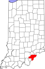
 Location within the U.S. state of Indiana | |
 Indiana's location within the U.S. | |
| Coordinates: 38°29′N 85°43′W / 38.48°N 85.72°W | |
| Country | |
| State | |
| Founded | February 3, 1801 |
| Named for | General George Rogers Clark |
| Seat | Jeffersonville |
| Largest city | Jeffersonville |
| Area | |
| • Total | 376.45 sq mi (975.0 km2) |
| • Land | 372.86 sq mi (965.7 km2) |
| • Water | 3.60 sq mi (9.3 km2) 0.96% |
| Population (2020) | |
| • Total | 121,093 |
| • Density | 320/sq mi (120/km2) |
| Time zone | UTC−5 (Eastern) |
| • Summer (DST) | UTC−4 (EDT) |
| Congressional district | 9th |
| Website | www |
| |
Clark County is a county in the U.S. state of Indiana, located directly across the Ohio River from Louisville, Kentucky. At the 2020 census, the population was 121,093.[1] The county seat is Jeffersonville.[2] Clark County is part of the Louisville/Jefferson County, KY–IN Metropolitan Statistical Area.
- ^ "U.S. Census Bureau QuickFacts: Clark County, Indiana". census.gov. Archived from the original on August 6, 2023. Retrieved June 9, 2022.
- ^ "Find a County". National Association of Counties. Archived from the original on May 31, 2011. Retrieved June 7, 2011.
