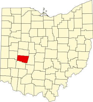
Clark County | |
|---|---|
 | |
 Location within the U.S. state of Ohio | |
 Ohio's location within the U.S. | |
| Coordinates: 39°55′N 83°47′W / 39.92°N 83.78°W | |
| Country | |
| State | |
| Founded | March 1, 1818[1] |
| Named for | George Rogers Clark |
| Seat | Springfield |
| Largest city | Springfield |
| Area | |
| • Total | 403 sq mi (1,040 km2) |
| • Land | 397 sq mi (1,030 km2) |
| • Water | 5.1 sq mi (13 km2) 1.3% |
| Population (2020) | |
| • Total | 136,001 |
| • Estimate (2023) | 134,610 |
| • Density | 340/sq mi (130/km2) |
| Time zone | UTC−5 (Eastern) |
| • Summer (DST) | UTC−4 (EDT) |
| Congressional districts | 10th, 15th |
| Website | www |
Clark County is a county located in the west central portion of the U.S. state of Ohio. As of the 2020 census, the population was 136,001.[2] Its county seat and largest city is Springfield.[3] The county was created on March 1, 1818, and was named for General George Rogers Clark,[4] a hero of the American Revolution. Clark County comprises the Springfield, OH Metropolitan Statistical Area, which is also included in the Dayton-Springfield-Sidney-OH Combined Statistical Area.
- ^ "Ohio County Profiles: Clark County" (PDF). Ohio Department of Development. Archived from the original (PDF) on April 21, 2007. Retrieved April 28, 2007.
- ^ 2020 census
- ^ "Find a County". National Association of Counties. Archived from the original on May 31, 2011. Retrieved June 7, 2011.
- ^ Gannett, Henry (1905). The Origin of Certain Place Names in the United States. Govt. Print. Off. pp. 82.

