45°46′N 122°29′W / 45.77°N 122.48°W
Clark County | |
|---|---|
 Clark County Courthouse | |
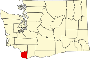
 Location within the U.S. state of Washington | |
 Washington's location within the U.S. | |
| Coordinates: 45°46′N 122°29′W / 45.77°N 122.48°W | |
| Country | |
| State | |
| Founded | August 20, 1845 as Vancouver District |
| Named for | William Clark on September 3, 1849 |
| Seat | Vancouver |
| Largest city | Vancouver |
| Area | |
• Total | 656 sq mi (1,700 km2) |
| • Land | 629 sq mi (1,630 km2) |
| • Water | 27 sq mi (70 km2) 4.1% |
| Population (2020) | |
• Total | 503,311 |
• Estimate (2023) | 521,150 |
| • Density | 770/sq mi (300/km2) |
| Time zone | UTC−8 (Pacific) |
| • Summer (DST) | UTC−7 (PDT) |
| Congressional district | 3rd |
| Website | clark |
Clark County is the southernmost county in the U.S. state of Washington. As of the 2020 census, the population was 503,311,[1] making it Washington's fifth-most populous county. Its county seat and largest city is Vancouver.[2] It was the first county in Washington, first named Vancouver County in 1845 before being renamed for William Clark of the Lewis and Clark Expedition in 1849. It was created by the Provisional Government of Oregon in Oregon Country on August 20, 1845, and at that time covered the entire present-day state.[3] Clark County is the third-most-populous county in the Portland-Vancouver-Hillsboro Metropolitan Statistical Area, and is across the Columbia River from Portland, Oregon.
- ^ "State & County QuickFacts". United States Census Bureau. Retrieved November 9, 2024.
- ^ "Find a County". National Association of Counties. Archived from the original on May 31, 2011. Retrieved June 7, 2011.
- ^ "Milestones for Washington State History — Part 1: Prehistory to 1850". HistoryLink.org. March 5, 2003.
