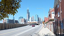
| George R. Clark Street 100 West (in the Loop) | |
 Clark Street at the Roosevelt Road interchange (October 2022) | |
| Coordinates | 41°56′54″N 87°39′27″W / 41.9483°N 87.6574°W |
|---|---|
| South end | Cermak Road (2200 S) |
| North end | Howard Street (7600 N) at the Chicago/Evanston border |
| Construction | |
| Inauguration | 1830 |
Clark Street is a north–south street in Chicago, Illinois that runs close to the shore of Lake Michigan from the northern city boundary with Evanston, to 2200 South in the city street numbering system.[1] At its northern end, Clark Street is at 1800 West; however the street runs diagonally through the Chicago grid for about 8 miles (13 km) to North Avenue (1600 N) and then runs at 100 West for the rest of its course south to Cermak Road. It is also seen in Riverdale beyond 127th street across the Calumet River, along with other nearby streets that ended just south of the Loop. The major length of Clark Street runs a total of 98 blocks.[1]
- ^ a b Hayner & McNamee 1988, p. 23