Clay County | |
|---|---|
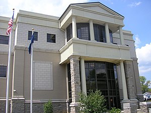
 Clay County courthouse in Manchester | |
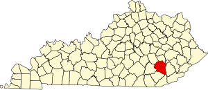
 Location within the U.S. state of Kentucky | |
 Kentucky's location within the U.S. | |
| Coordinates: 37°10′N 83°43′W / 37.16°N 83.71°W | |
| Country | |
| State | |
| Founded | 1807 |
| Named for | Green Clay |
| Seat | Manchester |
| Largest city | Manchester |
| Area | |
| • Total | 471 sq mi (1,220 km2) |
| • Land | 469 sq mi (1,210 km2) |
| • Water | 1.8 sq mi (5 km2) 0.4% |
| Population (2020) | |
| • Total | 20,345 |
| • Estimate (2023) | 19,648 |
| • Density | 43/sq mi (17/km2) |
| Time zone | UTC−5 (Eastern) |
| • Summer (DST) | UTC−4 (EDT) |
| Congressional district | 5th |
| Website | claycounty |
Clay County is a county located in the U.S. state of Kentucky. As of the 2020 census, the county population was 20,345.[1] Its county seat is Manchester.[2] The county was formed in 1807 and named in honor of Green Clay (1757–1826).[3] Clay was a member of the Virginia and Kentucky State legislatures, first cousin once removed of Henry Clay, U.S. Senator from Kentucky and Secretary of State in the 19th century.
- ^ "State & County QuickFacts". United States Census Bureau. Retrieved October 18, 2022.
- ^ "Find a County". National Association of Counties. Archived from the original on May 31, 2011. Retrieved June 7, 2011.
- ^ Rennick, Robert M. (1987). Kentucky Place Names. University Press of Kentucky. p. 59. ISBN 0813126312. Retrieved April 28, 2013.