Clearwater County | |
|---|---|
 Clearwater County Building and Courthouse in Bagley, Minnesota. | |
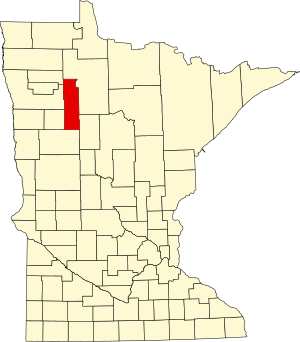
 Location within the U.S. state of Minnesota | |
 Minnesota's location within the U.S. | |
| Coordinates: 47°34′N 95°23′W / 47.57°N 95.38°W | |
| Country | |
| State | |
| Founded | December 20, 1902[1] |
| Named for | Clearwater Lake Clearwater River[2] |
| Seat | Bagley |
| Largest city | Bagley |
| Area | |
| • Total | 1,030 sq mi (2,700 km2) |
| • Land | 999 sq mi (2,590 km2) |
| • Water | 31 sq mi (80 km2) 3.0% |
| Population (2020) | |
| • Total | 8,524 |
| • Estimate (2023) | 8,644 |
| • Density | 8.5/sq mi (3.3/km2) |
| Time zone | UTC−6 (Central) |
| • Summer (DST) | UTC−5 (CDT) |
| Congressional district | 8th |
| Website | www |
Clearwater County is a county in the northwestern part of the U.S. state of Minnesota. As of the 2020 census, the population was 8,524.[3] Its county seat is Bagley.[4]
Clearwater County is home to Lake Itasca, the source of the Mississippi River. Parts of the Red Lake and White Earth Indian reservations extend into the county.
- ^ "Minnesota Place Names". Minnesota Historical Society. Archived from the original on June 20, 2012. Retrieved March 17, 2014.
- ^ Upham, Warren (1920). Minnesota Geographic Names: Their Origin and Historic Significance. Minnesota Historical Society. p. 121.
- ^ "State & County QuickFacts". United States Census Bureau. Retrieved April 8, 2023.
- ^ "Find a County". National Association of Counties. Archived from the original on May 31, 2011. Retrieved June 7, 2011.