| Clinch River | |
|---|---|
 The Clinch River at Speers Ferry in Scott County, Virginia | |
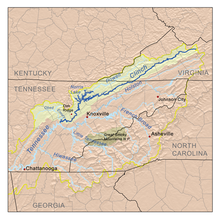
 Map of the Clinch River | |
| Location | |
| Country | United States |
| State | Virginia, Tennessee |
| Physical characteristics | |
| Source | Buckhorn Mountain near Tazewell, Virginia |
| • coordinates | 37°08′29″N 81°27′41″W / 37.14139°N 81.46139°W[1] |
| • elevation | 2,760 ft (840 m)[1] |
| Mouth | Tennessee River at Kingston, Tennessee |
• coordinates | 35°51′48″N 84°31′54″W / 35.86333°N 84.53167°W[1] |
• elevation | 741 ft (226 m)[1] |
| Length | 337 mi (542 km)[2] |
| Basin size | 4,413 sq mi (11,430 km2)[3] |
| Discharge | |
| • location | Grissom Island near Tazewell, Tennessee, 159.8 miles (257.2 km) above the mouth(mean for water years 1918-1983)[4] |
| • average | 2,100 cu ft/s (59 m3/s)(mean for water years 1918-1983)[4] |
| • minimum | 108 cu ft/s (3.1 m3/s) September 1925[4] |
| • maximum | 98,100 cu ft/s (2,780 m3/s) April 1977[4] |
| Basin features | |
| Tributaries | |
| • left | Little River, Beaver Creek |
| • right | Guest River, North Fork Clinch River, Powell River, Coal Creek, Poplar Creek, Emory River |
The Clinch River is a river that flows southwest for more than 300 miles (480 km) through the Great Appalachian Valley in the U.S. states of Virginia and Tennessee, gathering various tributaries, including the Powell River, before joining the Tennessee River in Kingston, Tennessee.
- ^ a b c d U.S. Geological Survey Geographic Names Information System: Clinch River
- ^ This figure was obtained by adding the length of the Tennessee section of the river, indicated on the USGS topo map Looneys Gap (1:24,000) as just over 202 miles, to the length of the Virginia section, indicated as 135 miles at this Virginia Department of Game and Inland Fisheries website Archived 2015-03-23 at the Wayback Machine.
- ^ U.S. Geological Survey, "Introduction to the Upper Tennessee River Basin," 11 January 2013. Accessed: 5 June 2015.
- ^ a b c d United States Geological Survey, Water Resources Data Tennessee: Water Year 1983, Water Data Report TN-83-1, p. 131. Gaging station 03528000.