Clinton | |
|---|---|
| Village of Clinton[1] | |
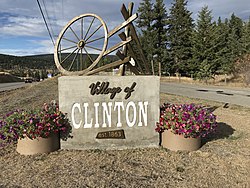
 Clinton's welcome sign | |
| Coordinates: 51°05′25″N 121°35′28″W / 51.09028°N 121.59111°W | |
| Country | Canada |
| Province | British Columbia |
| Regional district | Thompson–Nicola |
| Incorporated | 1963 |
| Government | |
| • Type | Mayor and Council |
| • Governing body | Clinton Village Council |
| • Mayor | Roland Stanke |
| Area | |
| • Total | 8.19 km2 (3.16 sq mi) |
| Elevation | 900 m (3,000 ft) |
| Population (2021) | |
| • Total | 568 |
| • Density | 78.2/km2 (203/sq mi) |
| -11.4% Population decrease from 2016 (641) | |
| Time zone | UTC−08:00 (PST) |
| • Summer (DST) | UTC−07:00 (PDT) |
| Area code | 250 |
| Highways | 97 |
| Website | http://www.village.clinton.bc.ca |
Clinton is a village in British Columbia, Canada, located approximately 40 km (25 mi) northwest of Cache Creek and 30 km south of 70 Mile House.
It is considered by some to straddle the southern edge of the Cariboo country of British Columbia, although others consider Ashcroft-Cache Creek, Lillooet, Savona, Kamloops and even Lytton and Spences Bridge to be in the Cariboo. Clinton, however, does sit immediately below the southern edge of the Cariboo Plateau. Clinton has a number of attractions including horse-back riding, big game viewing, hiking, fishing and other outdoor activities.
Every May, Clinton is home to the Annual Ball held on the Victoria Day weekend, where many people dress as the first settlers did. The Annual Ball kicks off the Village's Heritage week with the parade and the May rodeo and dance ending Heritage week. The Clinton Annual Ball is one of British Columbia's oldest continual events having first been held in 1867 and was a highlight of the social calendar in the British Columbia Interior for many decades.[2] The Clinton Museum, built in 1892, has a number of historical artifacts on display that date back to the gold rush and founding of the area.
- ^ "British Columbia Regional Districts, Municipalities, Corporate Name, Date of Incorporation and Postal Address" (XLS). British Columbia Ministry of Communities, Sport and Cultural Development. Archived from the original on July 13, 2014. Retrieved November 2, 2014.
- ^ The Cariboo Road, Mark S. Wade, publ. by Haunted Bookshop, Victoria
