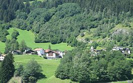
Clugin | |
|---|---|
 | |
| Coordinates: 46°37′N 9°26′E / 46.617°N 9.433°E | |
| Country | Switzerland |
| Canton | Graubünden |
| District | Hinterrhein |
| Area | |
| • Total | 2.49 km2 (0.96 sq mi) |
| Elevation | 1,013 m (3,323 ft) |
| Population (December 2007) | |
| • Total | 34 |
| • Density | 14/km2 (35/sq mi) |
| Time zone | UTC+01:00 (Central European Time) |
| • Summer (DST) | UTC+02:00 (Central European Summer Time) |
| Postal code(s) | 7442 |
| SFOS number | 3704 |
| ISO 3166 code | CH-GR |
| Surrounded by | Andeer, Casti-Wergenstein, Donat, Pignia |
| Website | www |
Clugin (Romansh: Clugen) is a village in the municipality of Andeer in the district of Hinterrhein in the Swiss canton of Graubünden. In 2009 Clugin merged with Andeer and Pignia to form the municipality of Andeer.[1]
- ^ Amtliches Gemeindeverzeichnis der Schweiz published by the Swiss Federal Statistical Office (in German) accessed 23 September 2009


