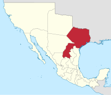
| Estado Libre y Soberano deCoahuila y Tejas Coahuila y Tejas | |||||||||||
|---|---|---|---|---|---|---|---|---|---|---|---|
| State of Mexico | |||||||||||
| 1824[1]–1835 | |||||||||||
|
Flag | |||||||||||
 Coahuila y Tejas within Mexico | |||||||||||
| Capital | SaltilloMonclova (March 9, 1833) | ||||||||||
| Demonym | Coahuiltejano | ||||||||||
| Area | |||||||||||
| 555,500 km2 (214,500 sq mi) | |||||||||||
• | 389,400 km2 (150,300 sq mi) | ||||||||||
• | 166,100 km2 (64,100 sq mi) | ||||||||||
| Population | |||||||||||
• | 70,955 | ||||||||||
| • Type | Federated state | ||||||||||
| Legislature | Unicameral Congress | ||||||||||
• Upper house | Congreso del Estado Libre y Soberano de Coahuila y Tejas[4] | ||||||||||
| History | |||||||||||
| September 27, 1821 | |||||||||||
• Established | May 7 1824[1] | ||||||||||
• Texas Revolution | October 2, 1835 | ||||||||||
• Disestablished | 15 December 1835 | ||||||||||
| December 29, 1845 | |||||||||||
| |||||||||||
| Today part of | Mexico - Coahuila United States - Texas | ||||||||||
| ^ a. Texas had approximately 389,400 km2 and Coahuila 166,100 km2. Texas had 18 municipalities: San Antonio de Bexar, 2,400; Goliad, 700; Victoria, 300; Saint Patrick, 600; San Felipe, 2,500; Columbia, 2,100; Matagorda, 1,400; Gonzalez, 900; Mine, 1,100; Nacogdoches, 3,500; San Augustine, 2,500; Liberty, 1,000; Johnsburg, 2,000; Anahuac, 50; Bevil, 140; Teran, 10; Tenaha, 100. | |||||||||||
Coahuila y Tejas, officially the Estado Libre y Soberano de Coahuila y Tejas (lit. 'Free and Sovereign State of Coahuila and Texas'), was one of the constituent states of the newly established United Mexican States under its 1824 Constitution.[5]
It had two capitals: first Saltillo (1822–1825) for petition[clarification needed] of Miguel Ramos Arizpe, that changing the capital for dispute of political groups, but Monclova recovered primacy because it was the colonial capital since 1689; this action provoked a struggle between the residents of Saltillo and Monclova in 1838–1840, but the political actions of Santa Anna convinced the monclovitas to accept the final change of political powers to Saltillo. In the case of Tejas its territory was organized for administrative purposes, with the state being divided into three districts: Béxar, comprising the area covered by Texas; Monclova, comprising northern Coahuila; and Río Grande Saltillo, comprising southern Coahuila.
The state remained in existence until the adoption of the 1835 "Constitutional Bases", whereby the federal republic was converted into a unitary one, and the nation's states (estados) were turned into departments (departamentos). The State of Coahuila and Texas was split in two and became the Department of Coahuila and the Department of Texas.
Both Coahuila and Texas seceded from Mexico because Antonio López de Santa Anna attempted to collect taxes, end slavery, and centralize the government, and groups of rebels, led primarily by immigrants and slave-owners, were unwilling to obey the laws of the rest of Mexico. Texas eventually became the independent Republic of Texas, which in 1845 became a state of the United States of America. Coahuila joined with Nuevo León and Tamaulipas, to form the short-lived Republic of the Rio Grande.
- ^ "Las Diputaciones Provinciales" (PDF) (in Spanish). p. 15.
- ^ "Historia Legislativa del Congreso del Estado de Coahuila (Constitucion de 1824)" (in Spanish). Archived from the original on 2011-07-24.
- ^ "Las Diputaciones Provinciales" (PDF) (in Spanish). p. 76.
- ^ "Historia Legislativa del Congreso del Estado de Coahuila (15 de agosto de 1824)" (in Spanish). Archived from the original on 2011-07-24.
- ^ 5th. Article of Mexican Constitution of 1824 Archived 2018-08-16 at the Wayback Machine.
