45°05′24″N 74°11′07″W / 45.09000°N 74.18528°W
| Coaticook River | |
|---|---|
 | |
| Location | |
| Country | United States, Canada |
| Physical characteristics | |
| Source | |
| • location | Norton Pond, Essex County, Vermont |
| Mouth | |
• location | Massawippi River, Waterville, Quebec |
• elevation | 149 m (489 ft) |
| Length | 56 km (35 mi) |
| Basin size | 364 km2 (141 sq mi) |
| Basin features | |
| Tributaries | |
| • left | (from mouth) creeks: Bradley, Drouin-Prémont, Sévigny, Ferland, Rodrigue, Giroux, Bissonnette, Lafond, Sylvestre (crossing the border), Mesker Meadow creek (Meadow Brook in USA); United States: Gaudette Brook, Sutton Brook |
| • right | (from mouth) creeks: Saint-Michel, Bourdon-Drouin, branch Lachance, creek Cornoir, du Pont-Rouge, Grenier, Tremblay, Cushing, Verill; United States: Number Six, Number Five, Davis Brook, Station Brook |
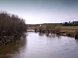
The Coaticook River is a north-flowing river rising in Vermont, United States, and located primarily in the Estrie region of Quebec, Canada. The mouth of the river is located north of Waterville and south of Lennoxville, near the southern border of the city of Sherbrooke, at the Massawippi River. Via the Massawippi and the Saint-François River, it is part of the St. Lawrence River watershed.