| Cobargo New South Wales | |||||||||||||||
|---|---|---|---|---|---|---|---|---|---|---|---|---|---|---|---|
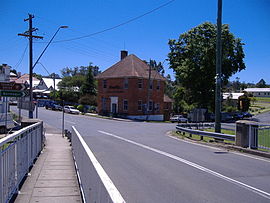
 View of Cobargo from the Princes Highway bridge | |||||||||||||||
| Coordinates | 36°22′S 149°54′E / 36.367°S 149.900°E | ||||||||||||||
| Population | 776 (2016 census)[1] | ||||||||||||||
| Postcode(s) | 2550 | ||||||||||||||
| Elevation | 81 m (266 ft) | ||||||||||||||
| Location | |||||||||||||||
| LGA(s) | Bega Valley Shire | ||||||||||||||
| State electorate(s) | Bega | ||||||||||||||
| Federal division(s) | Eden-Monaro | ||||||||||||||
| |||||||||||||||
Cobargo is a village in the south-east area of the state of New South Wales in Australia in Bega Valley Shire. At the 2016 census, Cobargo had a population of 776 people.[1] It is 386 km south of Sydney on the Princes Highway between Narooma and Bega. The town suffered heavy losses during the 2019 bushfires.
Cobargo's streetscape features turn of the century buildings. It has developed in the early 21st century from a sleepy and small village into a popular tourist destination. Its attractions include olden-style stores, leather craftworks, potteries, an iron forge, art galleries, tea rooms and antique shops. Wadbilliga National Park is 20 km west of Cobargo.
The name Cobargo may have originated from the local Indigenous Australian word 'cubago' which some sources claim was used to describe nearby Mount Gulaga.
- ^ a b Australian Bureau of Statistics (27 June 2017). "Cobargo (state suburb)". 2016 Census QuickStats. Retrieved 9 July 2017.
