Coffeyville, Kansas | |
|---|---|
 Sign at the west entrance (2016) | |
 Location within Montgomery County and Kansas | |
 | |
| Coordinates: 37°02′06″N 95°37′48″W / 37.03500°N 95.63000°W[1] | |
| Country | United States |
| State | Kansas |
| County | Montgomery |
| Founded | 1869 |
| Incorporated | 1873[2] |
| Named for | James A. Coffey |
| Government | |
| • Mayor | Ann Marie Vannoster [citation needed] |
| Area | |
• Total | 9.47 sq mi (24.52 km2) |
| • Land | 9.47 sq mi (24.52 km2) |
| • Water | 0.00 sq mi (0.00 km2) |
| Elevation | 735 ft (224 m) |
| Population | |
• Total | 8,826 |
| • Density | 930/sq mi (360/km2) |
| Time zone | UTC-6 (CST) |
| • Summer (DST) | UTC-5 (CDT) |
| ZIP code | 67337 |
| Area code | 620 |
| FIPS code | 20-14600 |
| GNIS ID | 485556[1] |
| Website | coffeyville.com |
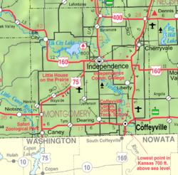
Coffeyville is a city in southeastern Montgomery County, Kansas, United States,[1] located along the Verdigris River in the state's southeastern region. As of the 2020 census, the population of the city was 8,826.[4][5] Coffeyville is the most populous city of Montgomery County, and the home to Coffeyville Community College. The town of South Coffeyville, Oklahoma is approximately 1 mile (1.6 km) south of the city.
- ^ a b c d U.S. Geological Survey Geographic Names Information System: Coffeyville, Kansas
- ^ Cite error: The named reference
histwas invoked but never defined (see the help page). - ^ "2019 U.S. Gazetteer Files". United States Census Bureau. Retrieved July 24, 2020.
- ^ a b "Profile of Coffeyville, Kansas in 2020". United States Census Bureau. Archived from the original on May 31, 2022. Retrieved May 31, 2022.
- ^ a b "QuickFacts; Coffeyville, Kansas; Population, Census, 2020 & 2010". United States Census Bureau. Archived from the original on August 26, 2021. Retrieved August 26, 2021.
