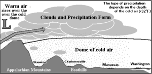
Cold air damming, or CAD, is a meteorological phenomenon that involves a high-pressure system (anticyclone) accelerating equatorward east of a north-south oriented mountain range due to the formation of a barrier jet behind a cold front associated with the poleward portion of a split upper level trough. Initially, a high-pressure system moves poleward of a north-south mountain range. Once it sloshes over poleward and eastward of the range, the flow around the high banks up against the mountains, forming a barrier jet which funnels cool air down a stretch of land east of the mountains. The higher the mountain chain, the deeper the cold air mass becomes lodged to its east, and the greater impediment it is within the flow pattern and the more resistant it becomes to intrusions of milder air.
As the equatorward portion of the system approaches the cold air wedge, persistent low cloudiness, such as stratus, and precipitation such as drizzle develop, which can linger for long periods of time; as long as ten days. The precipitation itself can create or enhance a damming signature, if the poleward high is relatively weak. If such events accelerate through mountain passes, dangerously accelerated mountain-gap winds can result, such as the Tehuantepecer and Santa Ana winds. These events are seen commonly in the northern Hemisphere across central and eastern North America, south of the Alps in Italy, and near Taiwan and Korea in Asia. Events in the southern Hemisphere have been noted in South America east of the Andes.