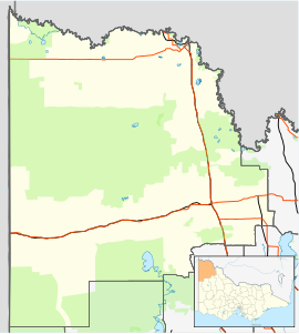
| Colignan Victoria | |||||||||||||||
|---|---|---|---|---|---|---|---|---|---|---|---|---|---|---|---|
 The Murray River flows through Colignan. This island, commonly known as Watts's or Colignan Island, is fully submerged when the river is high | |||||||||||||||
| Coordinates | 34°33′S 142°23′E / 34.550°S 142.383°E | ||||||||||||||
| Population | 305 (2021 census)[1] | ||||||||||||||
| Postcode(s) | 3494 | ||||||||||||||
| Location | |||||||||||||||
| LGA(s) | Rural City of Mildura | ||||||||||||||
| State electorate(s) | Mildura | ||||||||||||||
| Federal division(s) | Mallee | ||||||||||||||
| |||||||||||||||
Colignan is a small rural town on the banks of the Murray River, in North Western Victoria, Australia. The town is on the border of the Hattah-Kulkyne National Park. At the 2016 census, Colignan and the surrounding area had a population of 329.[1]
The closest town to Colignan is called Nangiloc which is Colignan spelt in reverse. It appears that Colignan predated Nangiloc, and Colignan is thought to have been the name of a local Aboriginal leader.
- ^ a b Australian Bureau of Statistics (27 June 2017). "Colignan (State Suburb)". 2016 Census QuickStats. Retrieved 31 December 2017.
