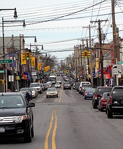
College Point | |
|---|---|
 College Point Boulevard | |
 Location within New York City | |
| Coordinates: 40°47′06″N 73°50′06″W / 40.785°N 73.835°W | |
| Country | |
| State | |
| City | |
| County/Borough | |
| Community District | Queens 7[1] |
| Named for | St. Paul's College |
| Population (2017 ACS Census)[2] | |
| • Total | 24,069 |
| Race/Ethnicity | |
| • Hispanic | 40.1% |
| • Asian | 34.3% |
| • White | 21.3% |
| • Other/Multiracial | 2.3% |
| • Black | 2.0% |
| Economics | |
| • Median income | $59,712 |
| Time zone | UTC−5 (Eastern) |
| • Summer (DST) | UTC−4 (EDT) |
| ZIP Code | 11356 |
| Area codes | 718, 347, 929, and 917 |
College Point is a working-middle-class neighborhood in the New York City borough of Queens. It is bounded to the south by Whitestone Expressway and Flushing; to the east by 138th Street and Malba/Whitestone; to the north by the East River; and to the west by Flushing Bay.[4] College Point is a mostly residential ethnically diverse community with some industrial areas. The neighborhood is served by several parks and contains two yacht clubs.
College Point is located in Queens Community District 7 and its ZIP Code is 11356.[1] It is patrolled by the New York City Police Department's 109th Precinct.[5] Politically, College Point is represented by the New York City Council's 19th District.[6]
- ^ a b "NYC Planning | Community Profiles". communityprofiles.planning.nyc.gov. New York City Department of City Planning. Retrieved April 7, 2018.
- ^ Cite error: The named reference
PLP5was invoked but never defined (see the help page). - ^ Cite error: The named reference
NYCDCD2020was invoked but never defined (see the help page). - ^ Shaman, Diana (May 26, 1985). "If You're Thinking of Living in College Point". The New York Times. p. R9. ISSN 0362-4331. Retrieved February 27, 2019.
- ^ Cite error: The named reference
NYPD 109th Precinctwas invoked but never defined (see the help page). - ^ Current City Council Districts for Queens County, New York City. Accessed May 5, 2017.